
Crossings: Getting Over, Around, and Through Water in Franklin County
One of the most important pathways in Franklin County’s early history is a natural river crossing that no longer exists.
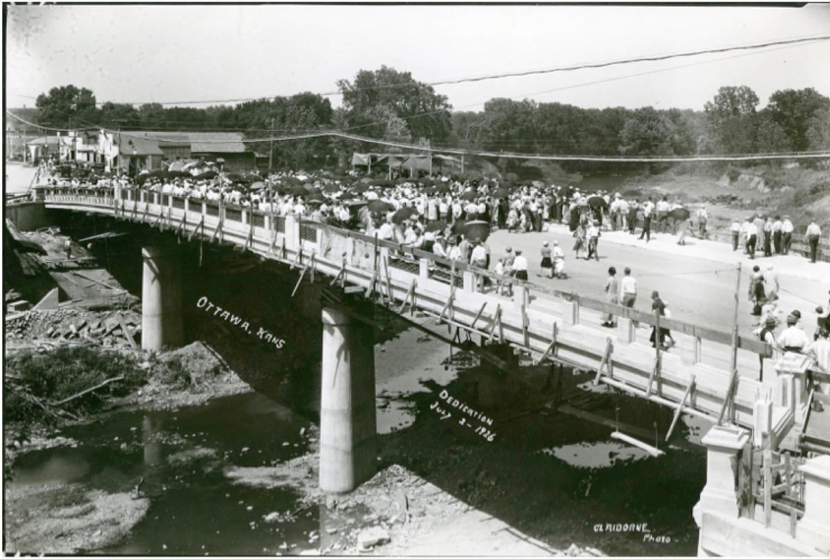
When the founders of the Ottawa Town Company were deciding where to establish their new town, they understood that access to a reliable source of water—for consumption, for agriculture, for transportation, for powering mills—was crucial to the long-term success of their town. The Marais des Cygnes River meandered through the center of Franklin County, nearly cutting it in half from west to east. But access to the river wasn’t enough; for a town to truly be successful, citizens needed an easy way to cross it. As a result, the Ottawa Town Company’s site was located alongside a natural ford that native and emigrant tribes used, as well as early Franklin County settlers on their way to the now defunct county seat of Ohio City—a ford that would become known as the Hickory Street Crossing.
Ottawa’s history—and indeed, Franklin County’s history—became inextricably intertwined with the temperamental river and the creeks that fed into it.
Unfortunately, the early town founders did not appreciate the danger they would bring to their fledgling town by settling inside one of the many crooks and bends of the Marais des Cygnes River. Ottawa’s history—and indeed, Franklin County’s history—became inextricably intertwined with the temperamental river and the creeks that fed into it. Floods repeatedly destroyed homes and businesses while further dividing the county by shutting down roads and bridges and washing away railroad tracks. Ottawa’s development into an unusually elongated town, stretching north and south, reflects the town’s effort to move away from the river without abandoning it completely.
Crossings: Getting Over, Around, and Through Water in Franklin County takes a closer look at the relationship Franklin Countians have with the Marais des Cygnes River. The exhibit documents old town sites developed around water crossings, including the original Ottawa Mission site, which was destroyed by a flood in 1844. It also examines the crossing at Hickory Street, a ford that was in use until it was destroyed by the completion of the levee system in the 1960s.
Crossings also explores the story of the river. The exhibit draws from the Franklin County Historical Society’s collection of nearly 1,200 photographs of floods, as well as the photographs, maps, and artifacts documenting the shifting of the river channel, the creation and marooning of the Island, and the sometimes controversial construction of flood control measures and the levee system that would both save and further divide northern and southern Ottawa. The exhibit takes a closer look at how Franklin County continues to control, protect, and respect the Marais des Cygnes River as both a source of safe drinking water and a site for recreation, and visitors are encouraged to consider how the construction and destruction of river crossings influences the development, success, or demise of communities.
Article contributed by the Franklin County Historical Society.
Image courtesy of the Franklin County Historical Society.